Signed in as:
filler@godaddy.com

Tubac Nature Center Hours
Wednesday 10:00 AM - 12:00 PM
Saturday 10:00 AM - 12:00 PM
Announcements and Ramblings
TUBAC NATURE CENTER JOURNAL - THE QUIET ONES
A group of Tubac birders met in November, 2017 to explore the possibility of starting a nature center. We had enthusiasm, energy, and an idea. A key missing element was money. Several weeks into the process, as the word got around the community about our idea, I received a phone call from a man I knew only by sight but had never spoken to. He said that he thought the nature center was one of the best ideas for Tubac that he had heard in while. He asked what he could do. I said we needed funding. He said let me know how much and get back to me. After some rough guessing and calculations, I called him back and said we needed about $10,000 to get off the ground. He said, “We have a lot of friends in the area, we will see what we can do.
After Bob Schuyler contacted his friends, the checks began to roll in. Shortly, we had $8400 donated, and certainly enough to get the process of forming the nature center off the ground. In the following months, we turned to Bob and his wife, Marty, for advice several times to solve minor and more significant issues. They never hesitated to help. Bob served on the board of directors for a period, convinced his friend, Dick Taggart, to step in to become our second Treasurer, and called occasionally with advice.
Last week Bob passed away! A very sad event for many of us, and especially for his family. There are so many people like Bob and Marty who pitch in quietly to make their communities better, getting little notice, and few “thank you’s.” Let’s take a moment to raise of glass to Bob, and to all the Bobs and Martys who quietly and with dedication make their communities the great places we live in.
Jim Karp
Tubac Nature Center
June 9, 2026
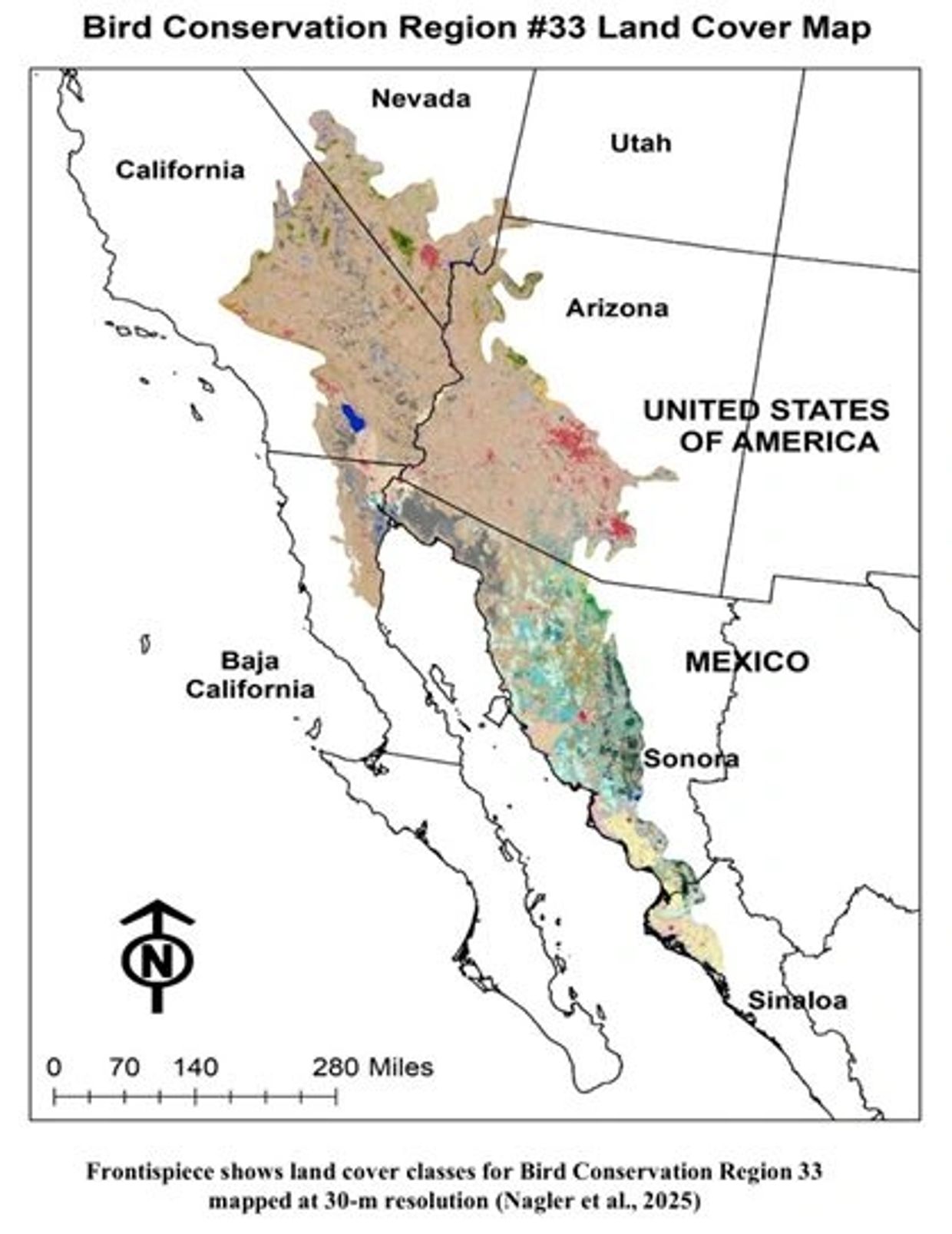
· Exciting news for desert bird and habitat conservation!After years of collaboration among USGS, the University of Arizona, Wildlands Network, and the Sonoran Joint Venture, a new high-resolution transboundary vegetation community map has been completed for Bird Conservation Region 33, covering large portions of the Sonoran and Mojave Deserts across the U.S.–Mexico border.This 30-meter resolution binational land cover map is the first known dataset of its kind for this region, using a consistent classification system across both countries. The map identifies 152 land cover classes across more than 38 million hectares, providing an important new tool for conservation planning, habitat restoration, and recovery efforts for migratory birds and other species.The interactive map and report will help partners, land managers, and researchers better understand vegetation communities across this vulnerable desert region and support cross-border conservation work.Many partners and contributors made this effort possible, including Dr. Pamela Nagler, Dr. Kamel Didan, Dr. Armando Barreto-Munoz, Myles Traphagen, Madeline Melichar, Eduardo Jiménez Hernández, Dr. Daniel Bunting, and the many graduate students, post-docs, and collaborators involved.This work was funded in part by the Science Support Partnership Program, a nationwide collaboration supported by the USGS Ecosystems Mission Area, through which USGS and U.S. Fish and Wildlife Service staff address priority research needs identified by FWS.Explore the resources:
Full report:
https://iris.fws.gov/APPS/ServCat/Reference/Profile/178257 Interactive map:
University of Arizona VIP research \\https://vip.arizona.edu/viplab_data_explorer.php... #PartnersInFlight
#BirdConservation #MigratoryBirds #SonoranDesert #MojaveDesert #HabitatConservation #TransboundaryConservation #USGS #UniversityOfArizona #SonoranJointVenture #WildlandsNetwork
It has been hard to keep this secret from you for the last several months. But I can finally share that HawkWatch International has a new Roost!
Late last year, a generous individual donated a 16-acre property to HWI in Tucson, Arizona. The property—to be called The Roost—will serve as the hub for our programs Arizona, and will build on 35+ years of work in the state, from the Grand Canyon HawkWatch to the forest owls we follow in the Chiricahua Mountains.
You can read more about this transformational gift here: https://hawkwatch.org/hwi-acquires-theroost/
HOW TO WATCH HAWKS FOR BEGINNERS : You’ll learn where to find a good spot to watch the migration (even if a hawkwatch doesn't currently exist near you), what gear to bring, resources to help ID distant birds, and more! Check it out here:
https://hawkwatch.org/how-to-hawkwatch-a-beginners-guide-to-observing-raptors/


We are not witnessing a simple fluctuation.
We are witnessing a steady disappearance.
In just one human generation, about one in four birds in North America has vanished. Since 1970, the continent has lost roughly 2.9 billion birds.
As the sun rises across March landscapes, the first “vanguard” migrants begin arriving in the United States—cranes, blackbirds, and meadowlarks returning to their breeding grounds. But long-term monitoring and recent reporting confirm a troubling reality: many bird populations across North America are declining, and some losses are accelerating.
Even familiar species are affected. The shimmering blue of the Indigo Bunting, now preparing to migrate north from the Caribbean and Central America, is becoming a less common sight in summer fields and brushlands.
The Myth: “Bird Populations Naturally Fluctuate”
A common assumption is that bird numbers rise and fall naturally.
Because many people still see birds at backyard feeders, it can feel like ecosystems remain stable. But large-scale scientific surveys tell a different story.
The loss of 2.9 billion birds since 1970 reflects not only the disappearance of rare species. It represents a broad “thinning” of once-common birds—sparrows, warblers, blackbirds, and buntings that form the backbone of North America’s ecosystems.
The Scientific Reality: Multiple Pressures
Long-term studies across the continent reveal several key drivers behind these declines.
Grassland Habitat Loss
Grassland birds have experienced the steepest decline of any bird group. Species like meadowlarks and bobolinks have lost more than half of their populations (about 53%) since 1970 as prairies and open fields disappear.
Hazards Across Two Continents
Migratory birds face challenges across their entire journey. Species like the Indigo Bunting must navigate habitat loss in tropical wintering forests and intensive agricultural landscapes in North America where pesticides and habitat fragmentation reduce food and nesting sites.
Climate Timing Mismatches
Warming temperatures are shifting seasonal patterns. In some cases, insects emerge earlier in spring before long-distance migrants arrive, making it harder for parent birds to find the caterpillars their chicks need.
What Is Happening Right Now (Early March)
Across Central America and the Caribbean, millions of songbirds are preparing for migration.
The Weight Race
Many species are currently in hyperphagia—an intense feeding period where they rapidly store fat. These fat reserves will fuel the long flights north.
The Early Arrivals
Meanwhile, some birds are already establishing territories. The Eastern Meadowlark has begun singing across parts of the southern United States, claiming fence posts and open fields as breeding territory.
Each territory secured is a small victory for a group of birds working to maintain shrinking populations.
Why Bird Declines Matter
Birds are vital to the health of ecosystems.
Natural Pest Control
Many small songbirds consume hundreds to thousands of insects each week, especially during breeding season. Their presence helps regulate insect populations naturally.
Seed Dispersal and Plant Growth
Birds help move seeds across landscapes, allowing forests and grasslands to regenerate and maintain plant diversity.
Environmental Early-Warning System
Bird populations often respond quickly to environmental change. Their decline can signal deeper problems affecting entire ecosystems.
Small Actions That Can Help
Individual choices can make meaningful differences for migrating birds.
Replace Some Lawn with Native Plants
Native grasses, shrubs, and wildflowers provide food and shelter that sterile turf lawns cannot.
Make Windows Safer
During migration, millions of birds collide with glass. Window decals, screens, or patterned films can dramatically reduce strikes.
Reduce or Eliminate Pesticides
Insects are essential food for birds. Every pesticide-free yard helps maintain the food supply birds rely on.
Conclusion
The decline of North America’s birds is a quiet emergency.
When species like the Indigo Bunting or Meadowlark disappear, we lose more than beautiful songs. We lose essential partners in the ecosystems that support forests, farms, and wild landscapes.
As spring migration begins this March, millions of birds are returning north.
The question is simple:
Will the landscapes they return to still be able to support them?
The answer depends, in part, on the choices we make today.

Bathtub Tank
El Pilar and Bathtub Tank are landmarks centrally located in the upper basin of Adobe Canyon. Although both destinations can be reached from virtually any direction, this column describes the shortest, easiest and most direct route.
The hike to El Pilar and Bathtub Tank begins at the end of the Adobe Canyon Road (FR-234), which is in miserable condition and impassable for passenger cars, low-clearance vehicles, tricycles and less capable trucks and SUVs. The Adobe Canyon Road leaves Route 82 about a half mile south of Milepost 28. After turning onto Adobe Canyon Road, bear sharply to the right and drive approximately one mile, passing several private driveways. The good road ends where it turns sharply to the left and crosses a broad creekbed. After a couple hundred yards, the road turns sharply to the right, passes through a gate, and begins a precarious journey up Adobe Canyon. In a few minutes you enter the Coronado National Forest and pass FR-4088 on the right. Continue driving north past a sign stating that Adobe Canyon Road dead ends in three miles.
If you manage to drive to the end of FR-234, the hike to Bathtub Tank is less than half a mile. If you continue to El Pilar, add another half mile to your hike. If you decide to park somewhere along the road and walk to the end of FR-234, the mileage will obviously be longer. FR-234 ends approximately five miles northwest of Route 82. The road is narrow, rocky, rutted, and crosses Adobe Creek 23 times. There are large dips in the road at many of the creek crossings that you have to creep over, regardless of what kind of vehicle you are driving. A reasonably fast hiker can probably walk the road almost as fast as a cautious person can drive it.
Note that FR-234 ends in a circular turn-around large enough to accommodate several vehicles; however, the circle is a tight fit and could be a difficult maneuver for a long vehicle or one pulling a trailer.
The most direct route to Bathtub Tank and El Pillar is up the narrow west arm of Adobe Canyon, which leaves FR-234 a couple of hundred yards before the turnaround. There is no official trailhead marking the beginning of the route but the entrance to the canyon is obvious.
After approximately 220 yards of easy walking, you arrive at Bathtub Tank, which the Civilian Conservation Corp (CCC) constructed sometime in the early 1930s. The tub consists of a man-made 15-foot-long concrete dam across a narrow channel in a large, fortress-like outcrop of solid rock that nearly pinches off the canyon. A small reservoir resembling a bathtub sits between the concrete wall and the native rock. A sizable section of the wall has eroded away so the tub is not nearly as deep as when constructed. When the bathtub is full, water flows over the opening in the wall, creating a ten-foot-high waterfall spilling into a natural pond at the foot of the barrier. In the distant past, a galvanized pipe carried water from the tub into a concrete cattle trough at the base of the wall on the right side of the waterfall.
There is a securely mounted 12-foot-high steel ladder attached to the rock on the right side of the basin. To continue to El Pilar, climb the ladder and work your way over the rocky ledge above the tub and continue walking up the narrow gorge. Within a few minutes, El Pilar comes into view, although it may be difficult to see through the dense growth of trees and underbrush. El Pilar is a 50-foot-high sandstone spire standing guard over the narrow passageway between the grass-covered hidden valley above and the marshy lowland below. The CCC constructed a concrete dam next to El Pilar, creating a shallow reservoir (or tank) above it with the same purpose as Bathtub Tan: to store water. The dam actually adds a bit of charm to the area because a steady stream of water flows over the barrier, giving the large pool at the base of the wall a garden-like appearance. To reach the upper basin, follow a well-trodden path up a natural ramp on the right side of the spire to a wide, man-made slot in the otherwise solid rock wall between El Pilar and the adjacent hilltop. The upper basin is covered with tall grass growing in a moist bed of rich, loamy soil.
An alternate route to El Pilar and Bathtub Tank is up the narrow main arm of Adobe Canyon. This hike begins up a footpath off the north end of the turnaround and immediately enters a narrow drainage bordered with plants typical of the Sonoran Desert. The trail climbs over an embankment and then drops to the rocky bed of the drainage. Hike up the wash 25 feet to where the trail veers up the left bank and then quickly returns to the creek. The path winds back and forth across the wash several times over the next 200 feet and then climbs a steep hill on the left. About a third of the way up the hill, the trail passes through a hiker’s gate between two large posts and then climbs out of the drainage next to a fence on a narrow ridge resembling an earthen dam. Although the trail continues up the ridge approximately a mile to where it connects to FR-4088, do not follow the trail. Instead, make a sharp left turn and walk west across a narrow land bridge to an opening in a fence. Pass through the fence, drop about 20 vertical feet, and follow the path a couple hundred feet along the south edge of a grassy marsh to El Pilar.
Return the way you came or continue down the narrow canyon to the main arm of Adobe Canyon and then on to Bathtub Tank, FR-234, and your vehicle.
Did you enjoy this story?
For 16 years, the Patagonia Regional Times, a nonprofit newsroom, has been the only source of free local news in eastern Santa Cruz County. Your support helps us continue telling the stories of our neighbors—covering news, local government, arts, events, school sports, being a voice for local non-profits, and so much more.
Every donation, big or small, fuels our mission to inform and connect our community through the voices of talented citizen journalists—your neighbors—who bring you the stories you can’t find anywhere else.
If you believe in the importance of community news and want to continue reading stories like this one, please donate today. Together, we can keep telling the stories that shape our community and keep us connected.
If you can, please consider supporting us now, or better yet, support us each month by joining our Press Core program. Thank you.
Our local news coverage is funded by people like YOU. Will you help us keep our independent journalism free and open to all today?
READ PATAGONIA REGIONAL TIMES LINK:
El Jefe became famous after crossing into Arizona from Mexico in 2011. As the only known jaguar in the United States at the time, he quickly captured national attention, appearing on trail cameras, inspiring the documentary El Jefe of the Mountains, and becoming a symbol in the debate over development in the Santa Rita Mountains.
Take a closer look at the jaguar who became a star: https://bit.ly/4rDg8Zs
American Kestrel
(Falco sparverius)
The brightly colored American Kestrel is North America’s smallest falcon, measuring just 8 to 10 inches in length. They feed primarily on insects, small rodents and sometimes birds. This fierce hunter adapts well to human-influenced habitats and urban settings, but the species’ population is declining in many regions of the United States, including Arizona. Tucson Bird Count data show a sharp reduction in numbers locally since 2010. Kestrels suffer from habitat loss and a lack of available nest cavities. Fortunately, this species readily accepts human-crafted nestboxes.
Nestbox programs are currently supporting the American Kestrel around the country. Watch for these birds perching on utility wires or hovering in the sky as they search for prey below. You may hear them calling: klee-klee-klee.
HABITAT Kestrels prefer semi-open country of all kinds,
especially with available hunting perches providing views of surrounding land. In the Sonoran Desert kestrels frequently nest in flicker holes in saguaros. Kestrels also nest in urban and suburban palm trees, underneath untrimmed fronds.
BOX MOUNTING Boxes should be placed between10
and 20 feet high with a northern or eastern orientation. They can
be affixed to houses, trees or poles. Boxes should not be placed among dense trees or shrubs, an open flight path to the entrance of the box is a must.
NESTING FACTS Kestrel pairs in Arizona deserts begin
courtship in late winter. The male often performs impressive feats of aerial display. As the time for egg-laying draws near, the male provides more and more of the female’s daily food. Kestrels lay eggs as early as March, but the peak of the breeding season is in April and May. The birds use no nesting material, laying eggs on debris found naturally in cavities. For nestboxes, we recommend providing wood shavings to cushion the eggs. Kestrels may return to reuse the same nests, year after year. During the winter, kestrels sometimes roost in nestboxes and cavities.
Photos (top to bottom) by Doris Evans (female) and Alan Vernon / Flickr Creative Commons License (male), TAS webcam (pair). Text by Keith Ashley, Olya Weekley.
To learn more about the American Kestrel Partner- ship and the decline of this species, please visit kestrel.peregrinefund.org.
To begin contributing to American Kestrel conservation in Arizona or for more information contact us at raptors@azgfd.gov.
Together, we represent thousands of Pima and Santa Cruz County residents who want to see the river corridor protected in perpetuity. The Santa Cruz River Refuge coalition recognizes that the Santa Cruz River has been a storied spiritual and cultural place for the Tohono O’odham and their distinct ancestors, and Pascua Yaqui people from time immemorial. We recognize that the people of the San Xavier District, in particular, have ancestral ties to the flowing Santa Cruz River and the lands around it. The original homeland of the O’odham and their ancestors, including the Hohokam and Early Agricultural People, is located on the river, which they collectively have stewarded for millennia. They continue to access these lands for ongoing cultural and religious practices.
The ecologically and culturally rich Santa Cruz River flows through the heart of Tucson, a fast-growing city of over 1 million people in the greater metropolitan area. After generations of colonization and groundwater overuse, the surface flow stopped running in some areas, with flows all but drying up except during heavy seasonal rains. In 2012, Pima County approved funding to vastly improve the quality of wastewater effluent that was being released into the Santa Cruz River. By upgrading the wastewater treatment facilities—which currently release highly treated wastewater into the Santa Cruz—local leaders, alongside restoration volunteers, created over 25 miles of vibrant habitat that has been foundational to the recovery of native vegetation, wildlife, insects, and migratory bird species.
The Santa Cruz corridor offers abundant recreation opportunities, including birdwatching at Sweetwater Wetlands and cycling and walking along the beloved 137-mile Chuck Huckelberry Loop, a popular paved recreation trail with dozens of access points that runs alongside the Santa Cruz and its major tributaries.
Our vision for an urban national wildlife refuge imagines an archipelago of protected properties along the Santa Cruz River that would offer permanent wildlife habitat and outdoor access. The Tucson land would anchor this “string of pearls,” offering shade, river access, and outdoor education for the neighboring communities. The Santa Cruz River Urban National Wildlife Refuge draws inspiration and lessons from current exemplary restoration work happening along the corridor, including the San Xavier District’s Wa:k Hikdan project.

If you have a wildlife emergency, please call our 24/7 helpline at (520) 290-9453. We are available to answer calls and to offer advice. We will travel after hours for emergency wildlife situations if we are available and if the situation warrants. Our hours of admission/intake are from 8am to 5pm daily.

I don't suck blood and I don't want to get stuck in your hair.
If I accidentally walk into your house,
please don't hit me with sticks or brooms, it really hurts and I'm very scared.
It was an accident, I didn't want to scare you. If I land, I may not be able to get up and I need your help. Just use a towel to get me out and I'll fly right away, I promise. I eat mosquitoes and many other insects. Our houses are being demolished for other buildings and we only have a few places to shelter. so if I fly into your house, turn off the lights, leave the outside light on and leave the door open, I'll be out in a heartbeat.
Be a human, I want to live too..

A mother and her three nearly full grown kittens paid us a visit for a drink from the birdbath. This wasn't the first time, since a few mornings recently I found the birdbath bowl tipped onto the ground. I thought it must have been deer but now I know who the real culprit is. We live in Rio Rico on the western slope of the San Cayetano mountains overlooking the Santa Cruz river. These beautiful bobcats are just one example of the abundant and varied wildlife we enjoy on a daily basis. photo by BRUCE TILDEN

Leave out CLEAN water for birds in a bird bath or another type of clean ceramic dish. Remember that water can get moldy which can kill the birds, hummingbird sugar water too, so change it every other day.
PHOTO by Dick York

Do not run. Running into a large predator in the wilderness will instantly trigger your fight-or-flight instincts. Follow the former; do not ever turn and run from a cougar. This is certain to trigger the cat’s predator response — they almost universally take prey by chasing and attacking from behind.
Look big. Make yourself look bigger to the cat. Open your jacket, raise your arms and spread your legs, and face the lion at all times. If you have trek poles or any objects handy, wave them around — and be prepared to use them to defend yourself.
Make noise. Speak loudly, and make as much noise as possible. There are plenty of anecdotes of people scaring away mountain lions with loud music (Metallica, in particular) played from a speaker or smartphone.
Maintain eye contact. You may have been told that staring down an animal is considered a challenge that could invite an attack — especially with dogs — but, in this case, maintaining eye contact with the lion is a best practice.
Stand your ground. If the lion challenges you by approaching from a distance, stand your ground. To the lion, only prey animals retreat. Lions don’t recognize a standing human as a typical prey animal. Standing your ground reinforces this fact.
Do everything to fight back. Adult male lions weigh 135 to 175 pounds, while females weigh between 90 and 105 pounds. These are powerful creatures with sharp claws and strong bites, but they aren’t insurmountable — and, if you’re attacked, there’s nothing better to do than to fight back. Mountain lions usually attack the head and neck; do your best to protect these areas by remaining upright and facing the cat during the attack. Use any weapon available to you. A sharp crack to the skull with a rock, or a blow to the body with a pocket knife or any other sharp implement, could be enough to end the attack.
If you see a mountain lion near any area frequented by people, immediately contact your local authorities. If you’re near a state park or forest, contact park officials or your state’s Department of Wildlife. If no contact information for rangers or DNR services are available, or if you see a lion near an urban area, contact your local sheriff’s office or police department — they’ll either respond directly, or contact the appropriate wildlife service.
If you’ve ever gone owling, you know it is no easy feat. Owls are usually heard, not seen, mostly thanks to their great camouflage and typically nocturnal behavior. As you can imagine, this makes owls really hard to study and is why there are so many owl species we don’t know much about.
But thanks to your support, we can fund three incredible biologists studying owl species through the Global Raptor Research and Conservation Grant! For the first time in the grant’s history, no recipient is studying a species listed as Endangered or Critically Endangered; however, these projects will fill critical knowledge gaps necessary for the conservation of these species. Click here to learn more about these projects and why they were selected: https://hawkwatch.org/the-year-of-the-owl-the-2026-winners-of-the-global-raptor-research-and-conservation-grant/
When we’re not funding grantees, we are looking for other ways to support international research. One way is selling merchandise featuring beloved species, such as the Bearded Vulture. Right now, we are running a spring-cleaning sale, where we are marking select items—including our Bearded Vulture tee—40% off! The discount is applied automatically at checkout. Click here to help us clear house and support conservation: https://hawkwatch-international.myshopify.com/collections/spring-cleaning-2026-products
Yours in conservation,
Sammy
--
Sammy Riccio (she/her)
Communications Manager
P.S. The African Raptor Leadership Grant is now accepting applications! This grant helps fund research projects for MSc or Honors students at universities in Nigeria, Morocco, and South Africa. Click here to learn more: https://raptorresearchfoundation.org/grants-awards/african-raptor-leadership-grant/
I was recently asked by someone "how can I help the birds?" While it is sometimes easy to feel helpless, there is so much you can do!! Here are some tips:
- Vote for and support people and organizations who will fight climate change. Climate change is the number one existential threat for not just birds, but all living things, including us.
- Support bird conservation organizations at the local, state, and national levels.
- Keep cats indoors and learn how to protect birds from window strikes.
- Educate yourself about birds, as well as the healing and wellness power of birds and nature so you can educate others.
- Participate in HawkWatch, Citizen Science, such as Project FeederWatch and eBird so scientists can learn more about how birds are doing and what they need.
- Create a bird sanctuary in your own yard with native plantings to help resident, migrating, wintering, and breeding bird species.
- Feed the birds and learn best bird feeding practices to successfully attract the most birds and keep them safe.
- Mentor someone and help them learn about birds, including kids!!


In Southern Arizona, monsoon rains usually come in early July, although the official monsoon season kicks off on June 15 and runs through September 30, with many factors throughout the spring and early summer influencing its exact start. The word monsoon is derived from the Arabic word mausim, which means season. Monsoon thunderstorm activity accounts for two-thirds to three-fourths of the annual precipitation in Southern Arizona, where short-lived, intense monsoon thunderstorms can cause flash flooding in areas with steep terrain, low-lying roads, or normally dry washes. Lightning, hail, dust storms, and strong winds often occur during the monsoon season. Furthermore, it is incorrect to call a single thunderstorm a “monsoon,” rather it is a large-scale weather pattern that causes these thunderstorms.
The dew point can help predict when the monsoon is likely to start. When the dew point hits 55 degrees on three consecutive days, the chance of monsoon rain is high.
Places to see waterfalls after a good rain:
Safety tips:
Water is life, but it's under threat in drought-stricken Arizona from mining and other industries. That's why the Patagonia Area Resource Alliance (PARA) is launching a Water is Life campaign to reform the laws and regulations that heavily favor mining in Arizona and allow for unlimited pumping of precious groundwater.
You know how vital clean, accessible water is to all life in Arizona. But current regulations simply aren't strong enough to prevent over-extraction that's drying up our aquifers and wells and devastating local ecosystems, especially given long term drought conditions. PARA is dedicated to protecting Arizona's water for generations to come. And your help is needed to make it happen. The only way to protect our region from Hermosa and looming future mines is to reform the state laws and regulations that heavily favor mining at the expense of water, air, healthy communities, wildlife and a sustainable economy.
Here's our plan to safeguard our water future:
Short–Term Goals
Long-Term Goals
“There is no justification for allowing one industrial project to undermine any community's future, especially under a legal loophole that permits extraction in the middle of a water crisis. The question isn't whether Arizona should mine copper and other minerals. It's whether we can afford to do it without rules that protect our shared resources and prioritize long-term public needs. We live in a desert. Water is life. Arizona's future depends on treating it that way.” - John Ball, Nogales resident, retired battalion chief and fire chief, testifying at a the Nogales City Council meeting
* We can't do this alone. We need the support of concerned citizens like you. The future of Arizona's water is at stake. You can help to create the changes needed to keep our water flowing for centuries to come.*
Please donate to our Water is Life campaign.
Your one-time tax-deductible gift will help kick start our Water is Life campaign, while a monthly gift will work wonders over time!
With gratitude from the entire PARA Watchdogs Team,
Anna, Joni, Carolyn, Laurie, Val, Chris, Sean, Richard, Markleigh and Cynie
P.S. Won’t you please support the Water is Life campaign today?
Water is Life: Don’t Mine it Away!